

By Gautam Sarmah
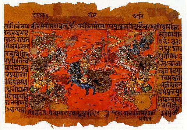
The historical geography of the Mahabharata period offers a wide and vivid picture of ancient India. The Mahabharata is not only a story of the Kauravas and the Pandavas; it is also an important geographical record of many kingdoms, peoples, rivers, mountains, and trade routes. Throughout its long narrative, it presents a political world stretching from the northwestern frontiers near present-day Afghanistan to the eastern lands of Bihar and Bengal, and from the Himalayan region to western and central India. The epic mentions many janapadas and kingdoms, showing that the land was divided into several political units, each with its own ruler, culture, and military strength. Although the exact date of the Mahabharata age remains debated, the places named in the text help us understand how ancient Indians imagined and remembered their world.
At the centre of the Mahabharata world stood Hastinapur, the capital of the Kuru kingdom. It is generally identified with present-day Hastinapur in the Meerut district of Uttar Pradesh. This region, near the upper Ganga basin, was one of the most important centres of early political power in northern India. In the epic, Hastinapur is the seat of the Kuru dynasty, from which both the Pandavas and the Kauravas came. Historically, the Kuru realm is important because it represents one of the earliest powerful states in the Indo-Gangetic plain and became deeply connected with ideas of kingship, dharma, and war.
Close to the Kuru land was Panchala, another major kingdom of the epic. Panchala is usually placed in western and central Uttar Pradesh, roughly between the Ganga and the Himalayan foothills, with northern and southern divisions. It is especially important in the Mahabharata because Draupadi, the wife of the Pandavas, was the princess of Panchala, and her father Drupada was one of the central political figures in the conflict. Panchala appears as a land of learning, martial power, and royal dignity. Its geographical position made it a bridge between the Kuru heartland and the eastern kingdoms.
Dwaraka, the famous city associated with Krishna, lay in the western coastal region of present-day Gujarat. It is linked with the ancient region of Anarta and the power of the Yadavas. In the Mahabharata, Dwaraka is both a sacred and political centre. Its maritime position suggests the importance of sea trade and western coastal connections in ancient India. Dwaraka’s historical importance lies in the way it connects epic tradition with the Arabian Sea coast and with a long and enduring religious memory in western India.
Gandhara was one of the most important northwestern kingdoms. It is generally identified with areas in present-day northwestern Pakistan and eastern Afghanistan, especially the regions near Peshawar and Taxila. In the Mahabharata, Gandhari, the queen of Dhritarashtra, came from this land, and Shakuni also belonged to Gandhara. This kingdom is historically significant because it linked India with Central Asia and Iran through major land routes. It stood at a cultural frontier where trade, warfare, and diplomacy met.
Anga was an eastern kingdom, usually identified with parts of present-day Bihar, especially around Bhagalpur and nearby areas. In the Mahabharata, it is closely associated with Karna, who was made king of Anga by Duryodhana. This gave Karna royal status and political honour. Anga was important because it lay on the eastern side of the middle Ganga plain and formed part of the wider eastern expansion of early states.
Matsya was another important kingdom and is generally located in present-day Rajasthan, especially in the region around Jaipur and Alwar. The Pandavas spent their final year of exile in the court of King Virata of Matsya. Because of this, Matsya occupies a memorable place in the epic. Historically, its position shows the connection between the Gangetic political world and the semi-arid regions to the west. It also reveals that the geography of the Mahabharata was not limited to the fertile plains but extended into varied landscapes.
Kamrupa is often included in discussions of epic geography from the northeastern side, though the older epic tradition is more directly connected with Pragjyotisha, the ancient kingdom associated with Bhagadatta. The later historical kingdom of Kamrupa developed in the Assam region, with its centre around Pragjyotishapura, identified with present-day Guwahati. Although Kamrupa as a named kingdom belongs to a later period, the epic memory of Pragjyotisha strongly connects the northeast with the world of the Mahabharata. This is historically important because it shows how Assam and the Brahmaputra valley were gradually woven into the larger political imagination of ancient India.
Magadha, located in southern Bihar with centres such as Rajgir and later Pataliputra, was one of the most powerful eastern kingdoms. In the wider history of India, Magadha later became the core of great empires such as the Mauryas, but even in the world reflected by epic and early traditions, it already stood out as a major political force. Its location in the lower middle Ganga valley gave it strategic and economic strength.
Kosala was situated in present-day eastern Uttar Pradesh and parts of the Awadh region, while Kashi centred on present-day Varanasi. Both were important cultural and political lands of ancient northern India. Their repeated appearance in early Indian traditions shows the importance of the middle Ganga basin as a zone of dense settlement, commerce, and sacred culture. Videha lay farther east in the Mithila region of northern Bihar and parts of Nepal. It is remembered as a land of learning and royal wisdom. Together, Kosala, Kashi, and Videha formed a chain of important eastern and northeastern states within the larger Gangetic civilisation.
Madra was located in the Punjab region, generally associated with parts of present-day Pakistani Punjab. It is remembered in the epic as the homeland of Madri, one of the wives of Pandu. Its location in the northwest once again shows how wide the geography of the Mahabharata was. Avanti, on the other hand, lay in western Madhya Pradesh, with Ujjain as its famous centre. Avanti was important because it connected northern India with the Deccan and western trade routes. Its inclusion in ancient political lists shows the growing importance of central India.
Sindhu and Sauvira belonged to the lower Indus region, largely in present-day Sindh and surrounding areas of Pakistan. These lands were important for river-based trade, agriculture, and contact with western regions. In the Mahabharata, Jayadratha, the ruler of Sindhu, plays an important role in the Kurukshetra war. Their presence in the epic highlights the geopolitical importance of the Indus basin. Surasena, usually identified with the Mathura region of Uttar Pradesh, was another key kingdom. Because Mathura was closely linked with Krishna traditions, Surasena occupied an important place in both political and sacred geography. Trigarta is generally associated with the Jalandhar-Kangra region of Punjab and Himachal Pradesh. It lay in the northwestern zone and was strategically important because it connected the plains with the Himalayan foothills.
Beyond these, the Mahabharata mentions many more kingdoms, such as Chedi, Vatsa, Malla, Vajji, Kamboja, Pundra, Vanga, Kalinga, Sivi, and Salva. Chedi is linked with Bundelkhand, Vatsa with the Kaushambi region, Kamboja with far northwestern areas near Afghanistan, Pundra with northern Bengal, Vanga with Bengal, and Kalinga with coastal Odisha. These references show that the epic preserves the memory of a vast political landscape made up of plains, river valleys, hill tracts, frontier regions, and coastal lands. Some were central powers, while others stood at the edges of the known world, yet all formed part of the imagined map of Bharatavarsha.
Thus, the historical geography of the Mahabharata period reveals far more than battle lines. It presents ancient India as a network of kingdoms connected by kinship, rivalry, pilgrimage, trade, and war. Hastinapur and Panchala formed the political heartland, Gandhara and Madra linked the northwest, Anga and Magadha represented the eastern rise of state power, Dwaraka opened the western coast, and Pragjyotisha, later associated with Kamrupa, extended the map toward the northeast. This wide spread of places gives the Mahabharata a unique civilisational depth. Even where legend and history meet, the geography of the epic remains a valuable guide to the political imagination of ancient India and to the early roots of regional identities that still survive in modern South Asia.
References:
1. Basham, A. L. The Wonder That Was India. London: Picador, 2004.
2. The History and Culture of the Indian People, Volume I: The Vedic Age. Mumbai: Bharatiya Vidya Bhavan, 1996.
3. Majumdar, R. C., ed. The Vedic Age. Mumbai: Bharatiya Vidya Bhavan, 1996.
4. Raychaudhuri, H. C. Political History of Ancient India. Revised edition. New Delhi: Oxford University Press, 1996.
5. Sharma, R. S. India’s Ancient Past. New Delhi: Oxford University Press, 2005.
6. Thapar, Romila. Early India: From the Origins to AD 1300. New Delhi: Penguin, 2002.
7. Upinder Singh. A History of Ancient and Early Medieval India: From the Stone Age to the 12th Century. New Delhi: Pearson, 2008.
8. Encyclopedia Britannica Pargiter, F. E. Ancient Indian Historical Tradition, Delhi: Motilal Banarsidass, 1997.
9. Dikshitar, V. R. Ramachandra. War in Ancient India. Delhi: Motilal Banarsidass, 1999.
10. Law, B. C. Ancient Indian Tribes. Delhi: Oriental Publishers, 1973.
11. Law, B. C. Geography of Early Buddhism. Delhi: Oriental Books Reprint Corporation, 1973.
12. Cunningham, Alexander. Ancient Geography of India. Varanasi: Indological Book House, reprint edition.
13. Sircar, D. C. Studies in the Geography of Ancient and Medieval India. Delhi: Motilal Banarsidass, 1971.